| Nr. |
Harta |
Linku |
Digjitalizimi |
Emri |
Autorësía |
Vendbotimi, botuesi |
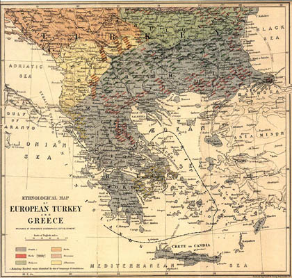
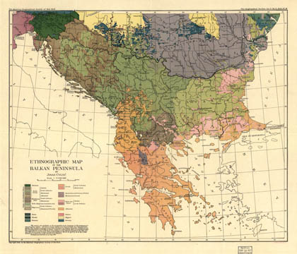
| 1 |
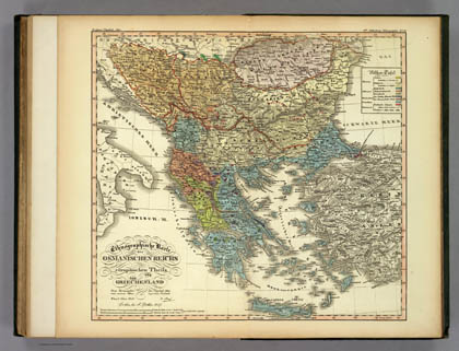 |
1840: Ami Boué |
Projektoje ›› |
Ethnographische Karte des Osmanischen Reichs europäischen Theils und von Griechenland (gjer.) |
Ami Boué |
Gotë, Justus Perthes |
| 2 |
 |
1861: Guillaume Lejean |
Projektoje ›› |
Carte éthnographique de la Turquie d'Europe et des états vassaux autonomes (fr.) |
Guillaume Lejean |
Gotë, Justus Perthes |
| 3 |
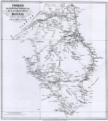 |
1861: Johann von Hahn |
Projektoje ›› |
Croquis des westlichen Gebietes der bulgarischen Morava (gjer.) |
Johann Georg von Hahn |
Vjenë |
| 4 |
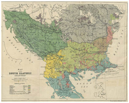 |
1867: Mackenzie, Irby |
Projektoje ›› |
Map of the South Slavonic Countries (ang.) |
G. M. Mackenzie, A. P. Irby |
Londër; Daldy, Isbister and Co. |
| 5 |
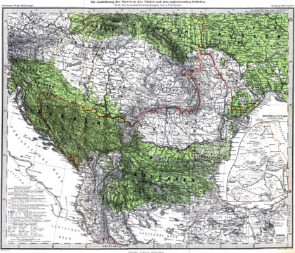 |
1869: August Petermann |
Projektoje ›› |
Die Ausdehnung der Slaven in der Türkei und den angrenzenden Gebieten (gjer.) |
August Petermann |
Gotë, Justus Perthes |
| 6 |
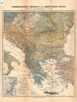 |
1876: Heinrich Kiepert |
Projektoje ›› |
Ethnographische Übersicht des Europäischen Orients (gjer.) |
Heinrich Kiepert |
Berlin, Dietrich Reimer |
| 7 |
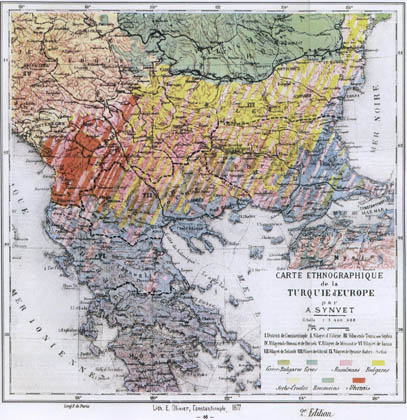 |
1877: Alexandre Synvet |
Projektoje ›› |
Carte ethnographique de la Turquie d'Europe (fr.) |
Alexandre Synvet |
Paris, A. Lassailly |
| 8 |
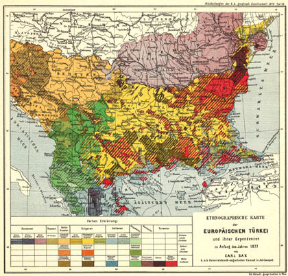 |
1877: Carl Sax |
Projektoje ›› |
Ethnographische Karte der Europäischen Türkei (gjer.) |
Carl Sax |
Vjenë, Monarkía e Dyfishtë |
| 9 |
 |
1877: Edward Stanford |
Projektoje ›› |
Ethnological map of European Turkey and Greece (ang.) |
Edward Stanford |
Londër, Stanford's Geographical Establishment |
| 10 |
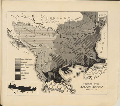 |
1878: Carl Sax |
Projektoje ›› |
Peoples of the Balkan Peninsula (ang.) |
Carl Sax |
Vjenë, Monarkía e Dyfishtë |
| 11 |
|
1878: Heinrich Kiepert |
Projektoje ›› |
Ethnographische Karte von Epirus (gjer.) |
Heinrich Kiepert |
Berlin, Dietrich Reimer |
| 12 |
 |
1880: Ernst Ravenstein |
Projektoje ›› |
Ethnographical map of Turkey in Europe (gjer.) |
Ernst Ravenstein |
pa të dhëna |
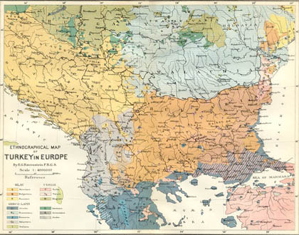
| 13 |
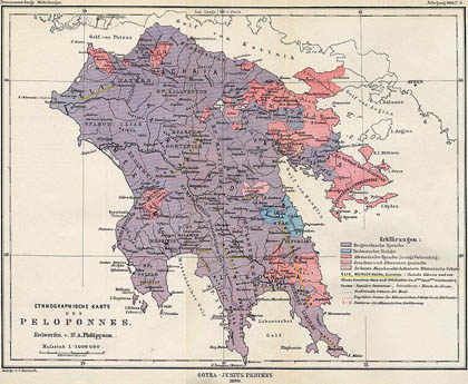 |
1890: Alfred Philippson |
Projektoje ›› |
Ethnographische Karte des Peloponnes (gjer.) |
Alfred Philippson |
Gotë, Justus Perthes |
| 14 |
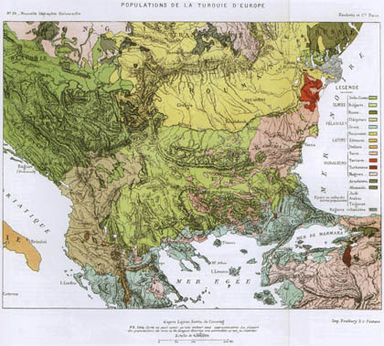
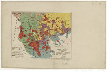
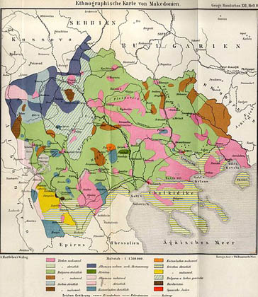 |
1892: Rundschau |
Projektoje ›› |
Ethnographische Karte von Makedonien (gjer.) |
shiko prejardhjen |
Deutsche Rundschau für Geogr. u. Stat. |
| 15 |
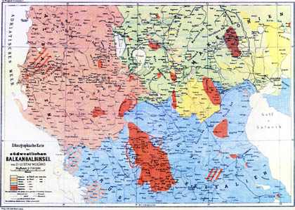 |
1894: Gustav Weigand |
Projektoje ›› |
Ethnographische Karte der südwestlichen Balkanhalbinsel (gjer.) |
Gustav Weigand |
Lajpcig, Johann Ambrosius Barth Verlag |
| 16 |
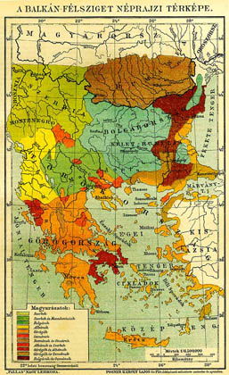 |
1897: Posner Lajos |
Projektoje ›› |
A Balkán-Félsziget Néprajzi Térképe (hun.) |
Posner Károly Lajos |
Budapesht, Pallas Nagy Lexikona |
| 17 |
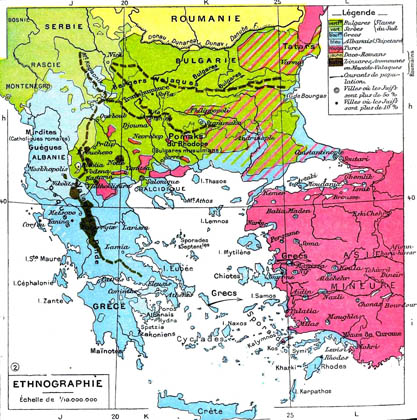 |
1898: Paul de la Blache |
Projektoje ›› |
Carte ethnique des Balkans (fr.) |
Paul Vidal de la Blache |
Paris, Librairie Armand Colin |
| 18 |
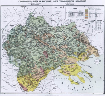 |
1900: Vasil Kançov |
Projektoje ›› |
Carte éthnographique de la Macédoine (fr.) |
Vasil Kançov |
Sofje |
| 19 |
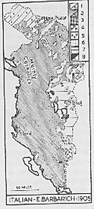 |
1905: Eugenio Barbarich |
Projektoje ›› |
Hartë nga libri "Albania" |
Eugenio Barbarich |
Romë, E. Voghera |
| 20 |
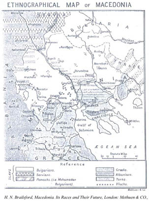 |
1906: Henry Brailsford |
Projektoje ›› |
Ethnographical Map of Macedonia (ang.) |
Henry Noel Brailsford |
Londër, Methuen & Co. |
| 21 |
 |
1909: Alfred Stead |
Projektoje ›› |
Ethnographical Map of Servia (ang.) |
Alfred Stead |
Londër, William Heinemann |
| 22 |
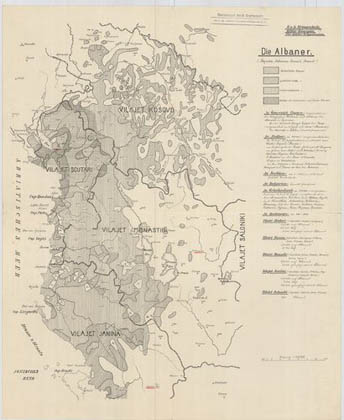 |
1910: Die Albaner |
Projektoje ›› |
Die Albaner (gjer.) |
|
pa të dhëna |
| 23 |
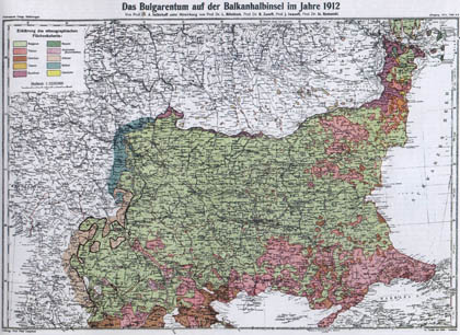 |
1912: Anastas Ishirkov |
Projektoje ›› |
Das Bulgarentum auf der Balkanhalbinsel im Jahre 1912 (gjer.) |
Anastas Ishirkov |
Gotë, Justus Perthes |
| 24 |
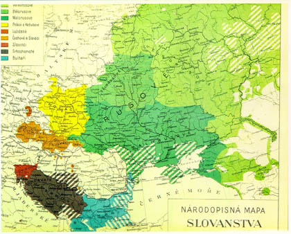 |
1912: Lubor Niederle |
Projektoje ›› |
Národopisná Mapa Slovanstva (çek.) |
Lubor Niederle |
Pragë, Laichter |
| 25 |
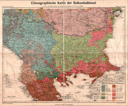 |
1913: Jovan Cvijiç |
Projektoje ›› |
Ethnographische Karte der Balkanhalbinsel (gjer.) |
Jovan Cvijiç |
Gotë, Justus Perthes |
| 26 |
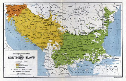 |
1913: J. Ivanov |
Projektoje ›› |
Ethnological map of the Southern Slavs (ang.) |
J. Ivanov |
Bernë, Lips |
| 27 |
 |
1913: N. Lako |
Projektoje ›› |
|
N. Lako |
Paris |
| 28 |
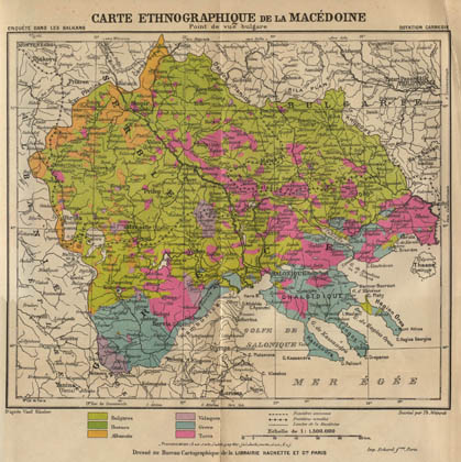 |
1914: Vasil Kançov |
Projektoje ›› |
Carte éthnographique de la Macédoine (point de vue bulgare) (fr.) |
Vasil Kançov |
Uashington, Carnegie Endowment for International Peace |
| 29 |
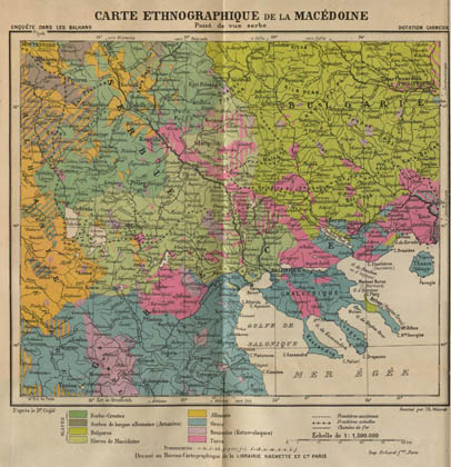 |
1914: Jovan Cvijiç |
Projektoje ›› |
Carte éthnographique de la Macédoine (point de vue serbe) (fr.) |
Jovan Cvijiç |
Uashington, Carnegie Endowment for International Peace |
| 30 |
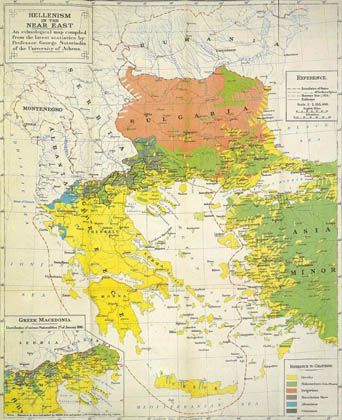 |
1916: George Soteriadhis |
Projektoje ›› |
Hellenism in the Near East (ang.) |
George Soteriadhis |
pa të dhëna |
| 31 |
 |
1918: Jovan Cvijiç |
Projektoje ›› |
Carte éthnographique de la Péninsule des Balkans (fr.) |
Jovan Cvijiç |
Paris, Librairie Armand Colin |
| 32 |
 |
1918: Jovan Cvijiç |
Projektoje ›› |
Ethnographic map of the Balkan Peninsula (ang.) |
Jovan Cvijiç |
pa të dhëna |
| 33 |
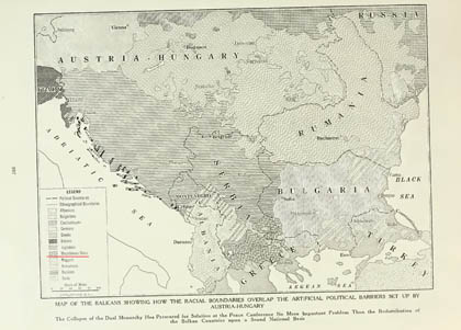 |
1918: Gazeta ASIA |
Projektoje ›› |
Map of the Balkans showing […] the racial boundaries […] (ang.) |
American Asiatic Association |
Nujork, Asia Pub. Co. |
| 34 |
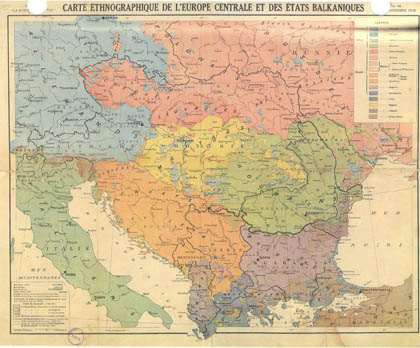 |
1918: Bolzé, Chesneau |
Projektoje ›› |
Carte ethnographique de l'Europe centrale et des Etats Balkaniques (fr.) |
René Bolzé, Marius Chesneau |
Paris, La Science et la Vie |
| 35 |
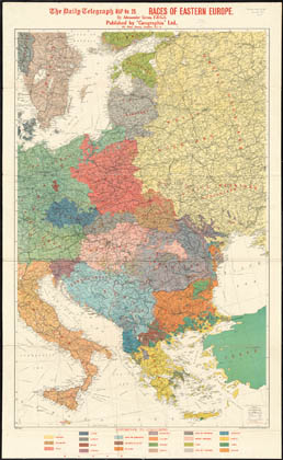 |
1918: Alexander Gross |
Projektoje ›› |
Races of Eastern Europe (ang.) |
Alexander Gross |
Londër; Geographia, Ltd. |
| 36 |
 |
1919: A. D. Atanasiu |
Projektoje ›› |
Carte éthnographique des Macedo-Roumains (fr.) |
A. D. Atanasiu |
Paris |
| 37 |
 |
1919: Julius Kettler |
Projektoje ›› |
Völkerkarte der Balkanhalbinsel (gjer.) |
Julius Iwan Kettler |
Berlin, Carl Flemming |
| 38 |
 |
1920: Jovan Cvijiç |
Projektoje ›› |
Etnografska skica Stare Srbije (serb.) |
Jovan Cvijiç |
pa të dhëna |
| 39 |
 |
1923: Caleb Hammond |
Projektoje ›› |
Racial Map of Europe (ang.) |
Caleb Stillson Hammond |
Nujork, C. S. Hammond & Co. |
| 40 |
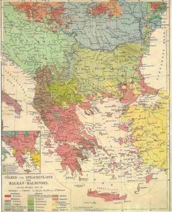 |
1924: Bibliogr. Institut |
Projektoje ›› |
Völker- und Sprachenkarte der Balkan-Halbinsel vor den Kriegen 1912-18 (gjer.) |
Bibliographisches Institut |
Lajpcig, Meyers Lexikon |
| 41 |
 |
1927: Leonhard Schultze |
Projektoje ›› |
Die volklische Zugehörigkeit der Dörfer im skopischen Feld zu seiten des Vardar (gjer.) |
Leonhard Schultze |
Jenë, Gustav Fischer |
| 42 |
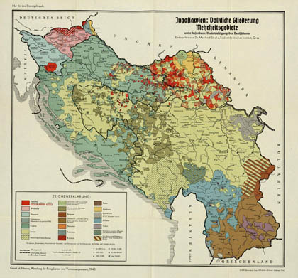 |
1940: Manfred Straka |
Projektoje ›› |
Jugoslawien: Volkliche Gliederung Mehrheitsgebiete (gjer.) |
Manfred Straka |
Grac, Südostdeutsches Institut |
| 43 |
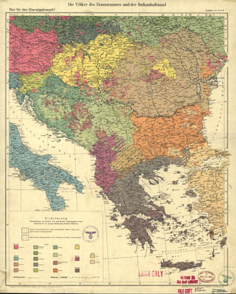 |
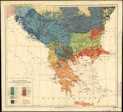
1940: Landesaufnahme |
Projektoje ›› |
Die Völker des Donauraumes und der Balkanhalbinsel (gjer.) |
shiko prejardhjen |
Berlin, Reichsamt für Landesaufnahme |